Table of Contents
Toggle🏎️ Why Ronda Requires a Hiking Strategy
To master the heights of the Tajo Gorge, you must first consult our Ultimate Ronda Travel Guide for a complete tactical briefing. While the Puente Nuevo bridge is the primary landmark, the gorge’s raw power is only truly understood from 120 meters below. Specifically, transitioning from an “urban mindset” to a “trail mindset” is a technical necessity before leaving the historic center to navigate the limestone verticality of the valley floor.
Logistical Access: Major trailheads are located within a 5-minute walk from the Ultimate Ronda Travel Guide territory.
Terrain Specifications: Expect a tactical mix of ancient cobblestones, packed dirt, and loose limestone scree that requires precision.
The Safety Reality: The gorge acts as a natural heat trap; temperatures on the trail are often 4°C to 6°C higher than at the bridge level.
Expert Tip: Centuries of foot traffic have polished the limestone in the Tajo Gorge, making it dangerously slippery even in dry conditions. Avoid flat-soled sneakers; a pair of trail shoes with multi-directional lugs is a technical necessity for the 180m vertical descent into the valley floor.
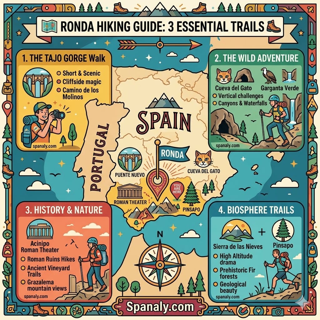
⚡ Quick Answer: The 3 Essential Hikes for Your Trip
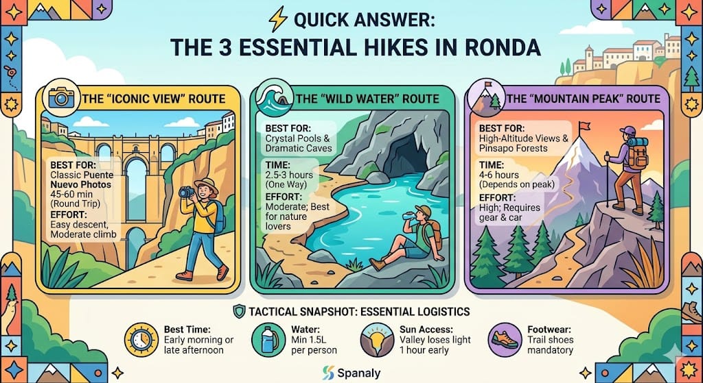
If you are operating on a tight schedule, these three routes provide the best technical and visual return based on your physical fitness and available time. Note that distances below reflect verified 2026 data:
The “Iconic View” (Camino de los Molinos):
Distance: 4 km (Round trip).
Est. Time: 1.5 hours.
Difficulty: Moderate (Steep Ascent). While the descent is manageable, the 180m vertical climb back to the city center places significant strain on the knees and requires steady pacing.
The “River Exploration” (Cueva del Gato):
Distance: 13 km (Linear path from Ronda center).
Est. Time: 4–5 hours.
Difficulty: Moderate/Hard. Due to the combined distance and high exposure to the sun along the valley floor, this route demands high endurance.
The “Summit Challenge” (Sierra de las Nieves):
Distance: 14 km (Return).
Est. Time: 6–7 hours.
Difficulty: Hard (Technical). Requires a 650m+ elevation gain and professional mountain gear to navigate sharp limestone ridges safely.
⚙️ Tactical Snapshot: Essential Logistics (2026)
| Feature | Requirement / Data | Tactical Reason |
|---|---|---|
| Best Window | 2 hours before Sunset | Avoids harsh shadows and peak thermal exposure on the gorge floor. |
| Water Intake | Minimum 2.0L per person | The 13km route (Cueva del Gato) has zero potable water points. |
| Light Loss | -90 minutes vs. City Level | Vertical canyon walls block direct light much earlier than official sunset. |
| Footwear | Multi-directional lugs | Polished limestone and loose scree require reinforced high-grip soles. |
Expert Tip: For high-quality photography, avoid hiking at solar noon. The vertical walls of the Tajo Gorge create massive shadows that obscure the architectural details of the bridge. Time your descent so you are at the valley floor exactly 90 minutes before sunset for the optimal golden-hour illumination on the stone.
📊 Hiking Trails Comparison Matrix: Technical Specifications
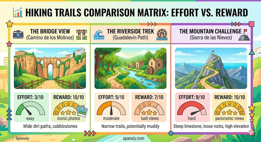
Selecting the appropriate trail in Ronda depends on your physical conditioning and the time window available in your Spain trip checklist. Use this matrix to evaluate the technical cost versus the logistical payoff of each route based on verified 2026 terrain data:
| Trail Name | Distance | Elevation Gain | Surface Type | Est. Time | Difficulty |
|---|---|---|---|---|---|
| Camino de los Molinos | 4.0 km | 180m | Cobblestone / Dirt | 1.5h | Moderate (Steep) |
| Cueva del Gato | 13.0 km | 120m | Riverbed / Gravel | 4.5h | Moderate/Hard |
| Acinipo Plateau | 4.0 km | 90m | Rocky / Exposed | 2h | Easy |
| Torrecilla Peak | 14.0 km | 650m+ | Loose Limestone | 6-7h | Hard (Technical) |
Expert Tip: While the city center is manageable in casual footwear, the surrounding Spanish attractions require a specialized technical approach. Even on shorter trails, the 180m vertical ascent back to the historic quarter can be physically demanding during peak thermal hours (12:00 PM – 4:00 PM). Always prioritize footwear with reinforced soles to mitigate the impact of sharp limestone and prevent joint strain during steep climbs.
🌉 The Iconic Tajo Gorge Walk: Camino de los Molinos
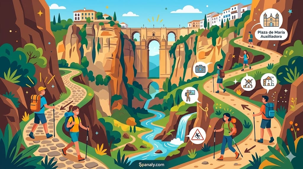
The Camino de los Molinos is the primary logistical route for accessing the base of the Puente Nuevo. It functions as a tactical descent from the historic quarter into the valley floor, offering a 180-meter vertical perspective of the cliffs and the bridge architecture. While the 4.0 km round-trip distance may seem manageable, the technical challenge lies in the steep ascent back to the city, which places significant pressure on the knee joints.
The Starting Point: Access begins at Plaza de María Auxiliadora in the Old Quarter. Look for the stone archway that marks the trailhead.
The Descent Specs: The path follows a zigzagging series of ancient cobblestones and packed dirt. Historically, this route serviced the flour mills (molinos) that sat directly beneath the Puente Nuevo Ronda guide area.
Technical Payoff: At approximately 1.5 km into the descent, you reach the open limestone plateaus. This is the optimal location for wide-angle photography of the bridge and the white houses of the “hanging” district.
Expert Tip: A secondary gate near the riverbank leads to the Guadalevín bank. However, the rocks here are permanently covered in moss and remain damp due to the waterfall’s spray. If you choose to exit the main trail for low-angle shots, ensure you maintain three points of contact. The combination of humidity and polished limestone makes the surface exceptionally slick, even in peak summer.
🥾 The Riverside Trek: Cueva del Gato Path
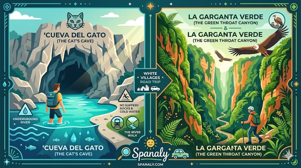
If your objective is to escape the urban heat, the route toward Cueva del Gato (Cat’s Cave) is the primary tactical choice. This trail connects Ronda to one of Andalusia’s most significant cave systems, following the natural flow of the Guadalevín river and the scenic railway lines.
Distance: 13 km (Linear from Ronda center).
Est. Time: 4.5 – 5 hours (Round trip requires a full-day commitment).
Terrain: Primarily flat riverbed paths, but with high sun exposure and sections of loose gravel near the railway.
Tactical Alternative: To optimize energy, you can take the local train to Benaoján-Montejaque station and hike the remaining 2 km to the cave, a strategy often recommended in our Ronda travel tips.
This route is a strategic addition if you are planning a white villages road trip from Ronda and want to experience the geological transition from the cliffs to the valley floor. Unlike the high-altitude peaks, this path offers a constant water-cooled microclimate near the resurgence.
Expert Tip: The water at Cueva del Gato maintains a constant temperature of 7°C (44°F) year-round. Entering the water after a high-exertion hike in 30°C weather poses a risk of thermal shock. Tactically, you should acclimate your body by wetting your wrists and neck first. Additionally, the limestone mouth of the cave is permanently damp; stay within the designated gravel areas to avoid falls on the jagged, “glassy” rock surfaces.
🏛️ Acinipo Ruins Hike: The Archaeological Plateau
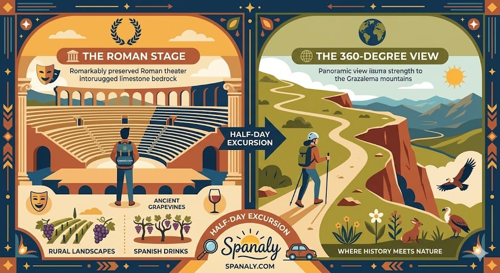
The hike to Acinipo is a high-priority route for those requiring a merge of archaeological data and rural trekking. Located on a limestone plateau at nearly 1,000 meters above sea level, this site features a remarkably preserved Roman theater carved directly into the bedrock. It serves as a technical alternative to the more crowded things to do in Seville or other urban hubs.
The Route: A 4.0 km loop through exposed vineyards and limestone ridges.
Est. Time: 2 hours (including site exploration).
Tactical Advantage: Unlike the Tajo Gorge, this area provides a 360-degree visual survey of the Grazalema mountains.
Historical Context: The theater dates back to the 1st century AD and utilizes the natural slope for its tiered seating (cavea).
This excursion is a primary choice for visitors interested in the historical origins of Spanish drinks, as the path winds through the high-altitude vineyards of the Serranía. Before heading out, ensure you consult our Spain trip checklist for the necessary sun protection gear.
Expert Tip: The Acinipo plateau is completely exposed with zero natural shade. Winds on the ridge are consistently 15–20 km/h stronger than in Ronda’s center, which accelerates dehydration even in cool weather. Tactically, you must carry a minimum of 1.5L of water and a windbreaker, as the temperature inversion on the plateau can lead to rapid heat loss once you stop moving.
🏔️ Sierra de las Nieves: Technical High-Altitude Trekking
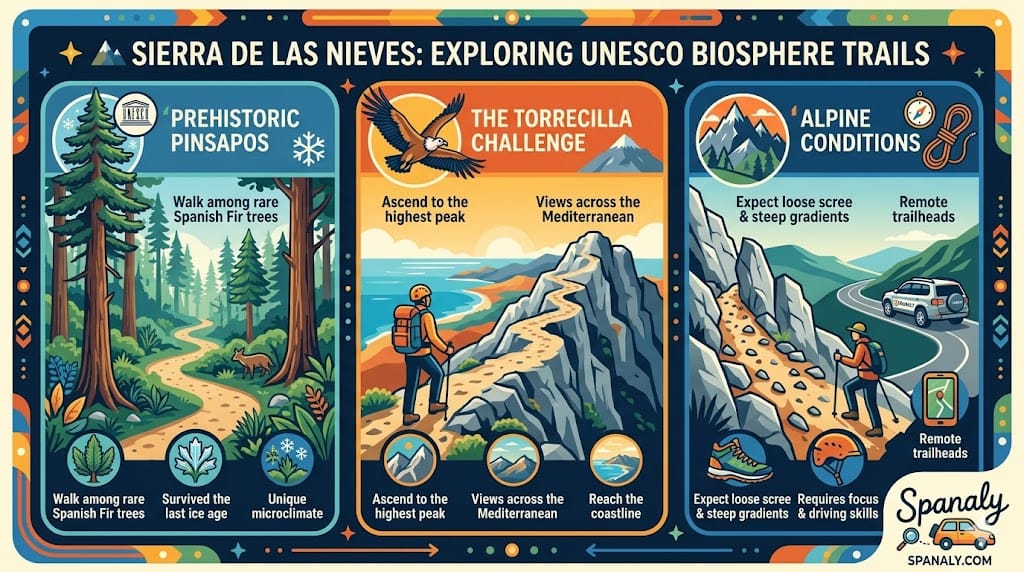
For hikers requiring a high-altitude challenge, the Sierra de las Nieves functions as the ultimate technical frontier in Andalusia. This UNESCO Biosphere Reserve marks a sharp transition from Ronda’s river valleys to rugged limestone peaks. It is a prioritized destination for those seeking a stark contrast to the urban energy found in things to do in Malaga.
The Challenge: Ascending to the Torrecilla Peak (1,919m), the highest point in Western Andalusia.
Distance/Time: 14 km (Return) / 6–7 hours depending on weather conditions.
Botanical Interest: The park protects the rare Abies pinsapo (Spanish Fir), a prehistoric conifer that survives only in specific high-altitude microclimates.
Terrain: Characterized by sharp limestone ridges, technical scree slopes, and steep gradients.
Reaching the trailheads requires driving in Spain through remote mountain roads (A-366). Given the isolation, this trek should only be attempted by those who have verified their equipment against our Spain trip checklist.
Expert Tip: Temperature inversion is a primary tactical risk here. While Ronda may be 25°C, the wind chill at Puerto de los Pilones can drop the “feels like” temperature to near freezing within minutes. Unlike the well-marked Spanish attractions, these mountain trails require a dedicated GPS unit; mountain mists can reduce visibility to less than 5 meters in seconds, making navigation by sight impossible.
📍 Trailhead Access: Reaching the Starting Points
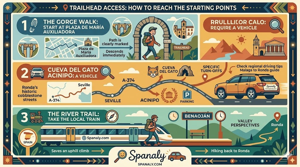
Identifying the precise coordinates for each trailhead is the first tactical step in Ronda’s rugged terrain. While some paths are accessible from the historic cobblestones, others require driving in Spain through rural mountain roads (A-374 / A-366).
The Tajo Gorge Walk: The access point is at Plaza de María Auxiliadora. Look for the stone archway; the path is clearly marked and initiates an immediate 180m descent into the valley floor.
Cueva del Gato & Acinipo: These sites require a vehicle. From Ronda, follow the A-374 toward Seville for approximately 15 km to reach the designated turn-offs. If you are still finalizing your transportation, consult our getting around Spain guide for regional logistics.
The River Path (The Train Strategy): A high-ROI tactical move is taking the local train from Ronda to Benaoján and hiking back to the city. This strategy eliminates the steep uphill climb and provides a continuous downhill perspective of the valley.
Expert Tip: Before heading to any trailhead, ensure your parking in Ronda is secured in a central garage like Martínez Astein. For those arriving from the coast, our Malaga to Ronda guide provides the technical data needed for navigating Andalusia’s high-altitude white villages.
🛡️ The Hiker’s Combat Kit: Gear, Safety & Level Selection
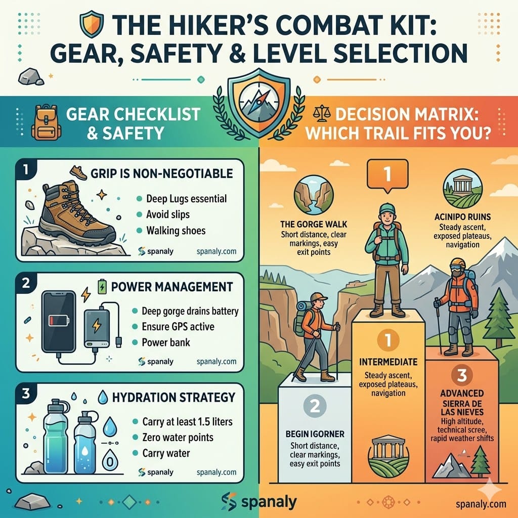
Success in Ronda’s limestone terrain depends on technical preparation rather than physical stamina. Whether you are descending into the Tajo or climbing the Sierra peaks, your equipment must align with the specific geological challenges of the Serranía.
Traction Requirements: The limestone paths near the gorge have become “polished” and glassy from foot traffic. High-performance trail shoes with multi-directional lugs are a mandatory requirement to mitigate slip risks.
Hydration & Thermal Load: There are zero potable water points once you leave the historic center. Carry a minimum of 1.5 liters per person. In summer, the gorge floor traps heat, creating a microclimate 4°C to 6°C hotter than the bridge level.
Power Management: Searching for a signal inside deep limestone walls accelerates phone battery depletion. A lightweight power bank is essential for maintaining GPS navigation on remote trails.
📊 Decision Matrix: Which Trail Fits Your Profile?
| Skill Level | Recommended Trail | Tactical Reasoning |
|---|---|---|
| Beginner | Camino de los Molinos | Short distance (3.5km), high visibility, and multiple exit points. |
| Intermediate | Acinipo Ruins Plateau | Flat terrain but high sun exposure (zero shade) and 1,000m altitude. |
| Advanced | Sierra de las Nieves | Technical limestone scree, high elevation (1,919m), and rapid weather shifts. |
Before finalizing your gear, cross-reference your equipment with our Spain trip checklist and ensure you have reviewed the travel safety in Spain protocols for mountain environments.
Expert Tip: Because of the vertical canyon walls, the valley floor loses direct sunlight 60–90 minutes before the actual sunset. Tactically, you must finish your return ascent by 4:00 PM in winter to avoid navigating the polished limestone paths in total shadow, where the risk of ankle injury increases due to low visibility.
🍽️ Post-Hike Recovery: Strategic Fueling in Ronda
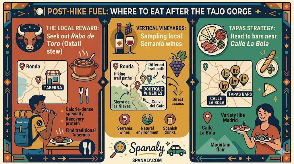
After completing the 180m vertical ascent from the Tajo Gorge, high-quality nutrient replenishment is a tactical necessity. Ronda’s culinary scene is heavily influenced by mountain-sourced proteins and seasonal produce, making it ideal for post-exertion recovery.
Nutritional Priority: Seek out Rabo de Toro (Oxtail stew), a calorie-dense local specialty high in collagen and protein, essential for muscle recovery.
The “Siesta Gap” Risk: Most traditional kitchens in Ronda close between 4:30 PM and 8:00 PM. If you finish your hike during this window, full meal service is unavailable. Your tactical best bet is a Taberna serving cold traditional Spanish food or Raciones.
Hydration & Mineral Intake: Many trails pass through vineyards producing high-altitude Serranía wines. While sampling Spanish drinks is part of the local Spanish cuisine experience, ensure you have stabilized your hydration with water first.
For a broader perspective on what to order, our Madrid food guide provides a baseline of Spanish classics, but in Ronda, the focus should remain on heavy mountain stews and local almonds for immediate energy.
Expert Tip: Avoid the primary “bridge-view” terraces for a full meal. These locations often prioritize the view over culinary precision. For authentic post-hike fuel, head to the streets near Calle La Bola. You will find higher-quality ingredients and more reasonable rates, especially during the peak Spanish festivals season when the center is over-capacity.
📅 The Seasonality Strategy: Best Times for a Stress-Free Hike
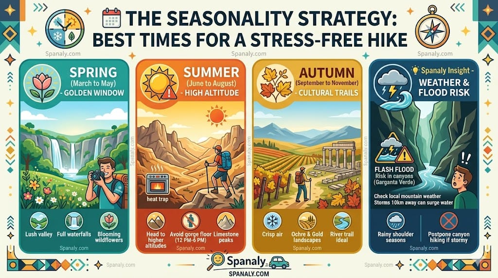
Timing is the most critical tactical variable in Ronda’s mountainous terrain. The Serranía operates on a distinct microclimate that differs significantly from the Andalusian coast. Aligning your trek with the best time to visit Spain is a baseline, but local mountain conditions require granular planning.
Spring (March to May): The optimal window for the Tajo Gorge. Waterfalls are at peak volume (3.5 – 5.0 m³/s flow rate), and the valley floor remains below 22°C.
Summer (June to August): Avoid the gorge floor between 12:00 PM and 6:00 PM. The vertical limestone walls trap heat, often reaching 38°C+, creating a hazardous “oven effect.” High-altitude trails in the Sierra de las Nieves are the only viable technical alternative.
Autumn (September to November): Ideal for the Acinipo ruins. The air clarity improves, but sunset occurs rapidly; ensure you’ve checked your Spain trip checklist for headlamps if hiking past 5:30 PM.
Expert Tip: The “Flash Flood” risk is a primary hazard in the narrow canyons of La Garganta Verde during the rainy shoulder seasons. Even if it is not raining in Ronda, a storm 10 km away can send a surge of water through the canyon in minutes. Tactically, if the sky turns dark over the mountains to the north, postpone any riverbed or canyon hiking immediately to avoid being trapped in the “surge zone.”
🛡️ Visitor FAQs – Ultimate Ronda Hiking & Safety Guide
🎒 Can I hike the Tajo Gorge with small children?
📶 Is there reliable mobile signal inside the canyons?
🐑 What should I do if I encounter livestock or guard dogs?
🎟️ Do I need a permit to hike in the National Parks?
🐍 Are there dangerous animals or snakes to watch out for?
Ronda Hiking Guide by Spanaly.com
Ronda functions as a high-value gateway to the geological and historical systems of Andalusia. To ensure a high-ROI (Return on Investment) experience, your choice of trail must align with your technical equipment and the current seasonal thermal load.
For High-Efficiency Visits: The Camino de los Molinos remains the non-negotiable choice for 60-minute itineraries.
For Technical Immersion: Sierra de las Nieves offers the most significant high-altitude data for experienced trekkers.
For Historical Depth: Acinipo is the primary alternative for merging rural hiking with archaeological exploration.
Logistics Reminder: Ensure your transportation and parking in Ronda are secured before initiating any descent. For those planning a broader regional exploration, our white villages road trip from Ronda guide provides the necessary data for navigating the surrounding limestone plateaus.