Table of Contents
Toggle🏔️ Picos de Europa
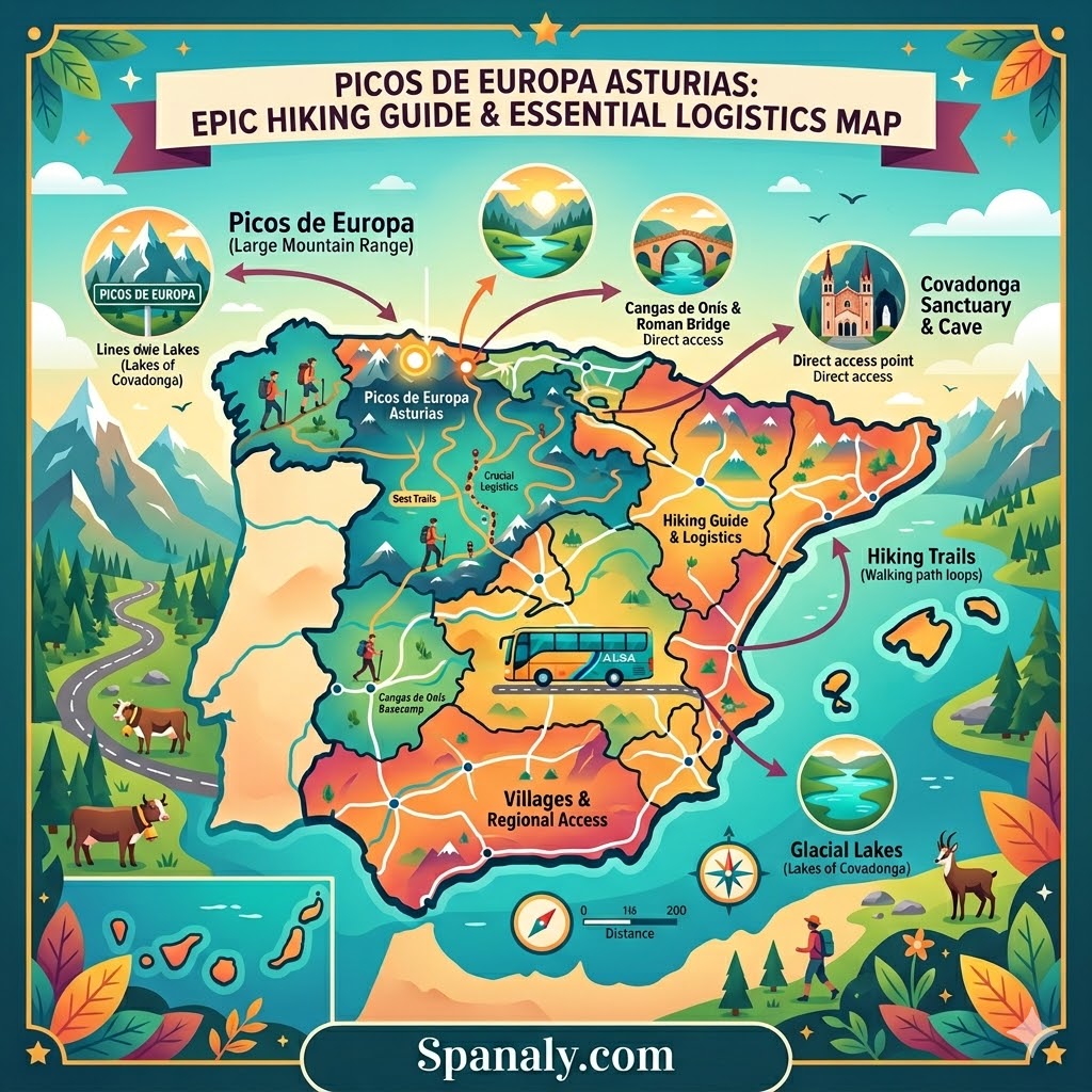
The Picos de Europa National Park in Asturias is not your typical Spanish getaway. It is a vertical world of jagged limestone, hidden hamlets, and deep-rooted mountain traditions that feel completely disconnected from the Mediterranean coast. This guide focuses on the Asturian massif, providing the essential logistics you need to navigate its high-altitude trails and remote villages.
🚌 Strategic Access: Master the transport rules for Poncebos and the Bulnes funicular to avoid logistical delays.
🥾 Iconic Hiking: Detailed planning for the Cares Route and the steep paths of the Central Massif.
🏡 Remote Living: Insights into visiting Bulnes, one of the last Spanish villages reachable only by foot or cable car.
🌍 Northern Context: To see how these peaks fit into your broader journey, consult our Ultimate Northern Spain Travel Guide for seamless regional planning.
Before we dive into the logistics, take a second to imagine the air here crisp, thin, and smelling of damp limestone. This is where the landscape stops being scenery and starts being a challenge.
📍 Picos de Europa Asturias: Essential Overview
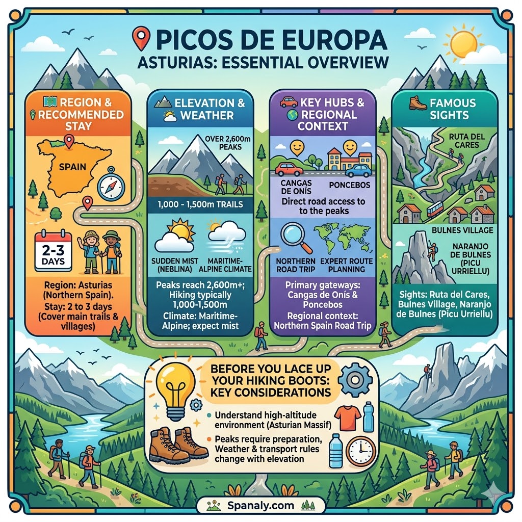
Before you lace up your hiking boots, you need to understand the high-altitude environment of the Asturian massif. These peaks require more preparation than a typical coastal walk, as weather and transport rules change with the elevation.
🗺️ Region: Asturias (Northern Spain).
🏔️ Elevation: Peaks reach over 2,600 meters; hiking trails typically sit between 1,000 and 1,500 meters.
⏱️ Recommended Stay: 2 to 3 days to cover the main trails and villages.
🌦️ Weather: Maritime-Alpine climate; expect sudden mist (neblina) even in mid-summer.
🚗 Key Hubs: Cangas de Onís and Poncebos serve as the primary gateways for the Asturias side.
🥾 Famous Sights: Ruta del Cares, Bulnes Village, and the Naranjo de Bulnes (Picu Urriellu).
🌍 Regional Context: To see how this mountain adventure fits into a broader trip, explore our Northern Spain Road Trip for expert route planning.
🏔️ Picos de Europa vs. The Alps: Which Mountain Escape Suits You?

The world often compares these peaks to the Alps, but the Picos de Europa carry a different kind of ancient, rugged weight. While both offer high-altitude drama, the choice depends on whether you prefer raw nature or polished infrastructure.
| Feature | Picos de Europa (Asturias) | The Swiss Alps |
| Atmosphere | Raw, mystical, and untouched. | Polished, postcard-perfect, and alpine. |
| Scenery | Glacial lakes and limestone crags. | Massive waterfalls and snowy peaks. |
| Accessibility | Strict shuttle bus & taxi system. | World-class train & cable car network. |
| Wildlife | Free-roaming cows & vultures. | Marmots and mountain goats. |
| Infrastructure | Minimal, preserving a sense of solitude. | High-end luxury resorts and cable cars. |
The Verdict: Which One Should You Choose?
Choose Picos de Europa if… you prefer a rugged and spiritual atmosphere where nature feels less commercialized.
Choose the Alps if… you are looking for high-end alpine infrastructure and a vast network of mechanical lifts.
Spanaly Insight: While the Alps are famous for their “organized” beauty, the Asturian peaks offer a unique sense of isolation. The lack of heavy commercial infrastructure makes the connection with the landscape feel much more authentic and raw.
🥾 Top Hiking Trails in Asturias: From Easy Walks to Rugged Treks
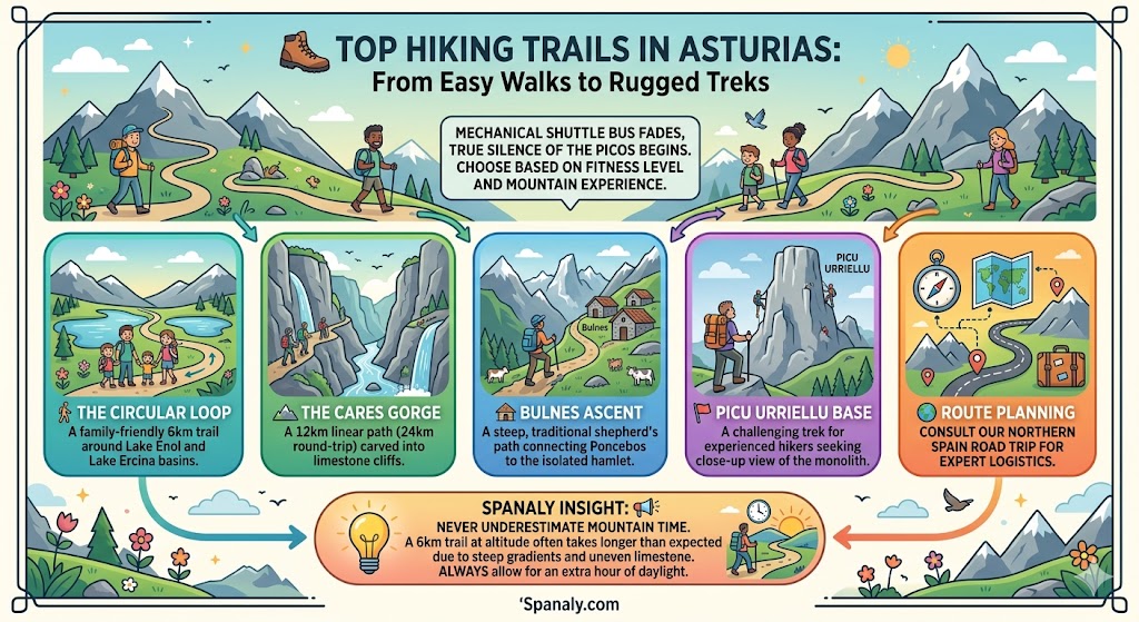
This is where the mechanical hum of the shuttle bus fades, and the true silence of the Picos begins. The Asturian side of the park offers a range of paths, but you must choose based on your fitness level and mountain experience.
🚶 The Circular Loop: A family-friendly 6km trail around the glacial basins of Lake Enol and Lake Ercina.
🏔️ The Cares Gorge: A 12km linear path (24km round-trip) carved into the limestone cliffs.
🛖 Bulnes Ascent: A steep, traditional shepherd’s path connecting Poncebos to the isolated hamlet of Bulnes.
🚩 Picu Urriellu Base: A challenging trek for experienced hikers seeking a close-up view of the iconic limestone monolith.
🌍 Route Planning: To see how these treks fit into a larger journey, consult our Northern Spain Road Trip for expert logistics.
Spanaly Insight: Never underestimate the mountain time. A 6km trail at this altitude often takes longer than expected due to steep gradients and uneven limestone terrain. Always allow for an extra hour of daylight.
🏞️ The Cares Route (Ruta del Cares): Logistics of the Divine Gorge
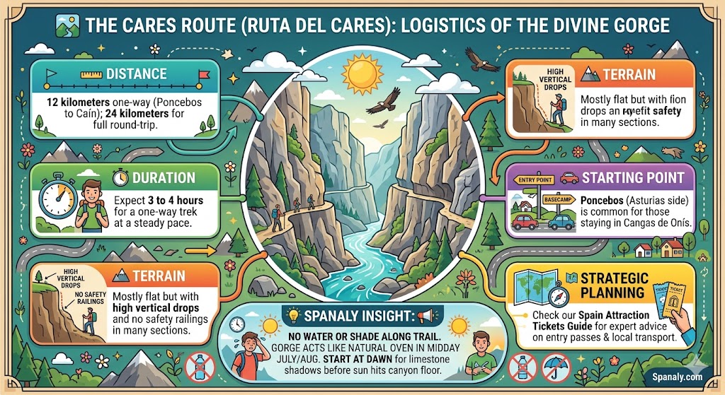
The Ruta del Cares is often called the “Divine Gorge,” but for hikers, it is a test of endurance and focus. This 12km path is carved directly into the limestone cliffs, offering a narrow, dramatic corridor between the mountains.
📏 Distance: 12 kilometers one-way (Poncebos to Caín); 24 kilometers for the full round-trip.
⏱️ Duration: Expect 3 to 4 hours for a one-way trek at a steady pace.
🏔️ Terrain: Mostly flat but with high vertical drops and no safety railings in many sections.
🚗 Starting Point: Poncebos (Asturias side) is the most common entry for those staying in Cangas de Onís.
🗺️ Strategic Planning: To manage your entry passes and local transport, check our Spain Attraction Tickets Guide for expert advice.
Spanaly Insight: There is no water or shade along the trail. The “Gorge” acts like a natural oven during midday in July or August. Start at dawn to experience the limestone shadows before the sun hits the canyon floor.
🏘️ Poncebos & Bulnes Village: Exploring the Heart of the Massif
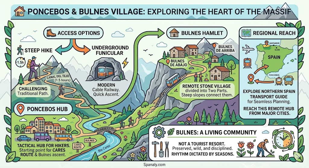
Poncebos serves as the primary tactical hub for hikers entering the central limestone massif. From this deep gorge, you can reach Bulnes—a village that remained accessible only by foot until the late 20th century.
📍 Poncebos Hub: This is the starting point for both the Cares Route and the ascent to Bulnes.
🛖 Bulnes Hamlet: A remote stone village divided into “Bulnes de Arriba” (higher) and “Bulnes de Abajo” (lower).
🥾 Access Options: You can choose the steep, 1.5-hour “Canal del Tejo” hike or the modern underground funicular.
🗺️ Regional Reach: To understand how to reach this remote hub from major cities, explore our Transport in Northern Spain guide for seamless planning.
Preserving a place this wild requires a bit of discipline and planning. Bulnes is not a tourist resort; it is a living mountain community where the rhythm is still dictated by the seasons.
🚠 Bulnes Funicular: Prices, Tickets, and Access Schedule
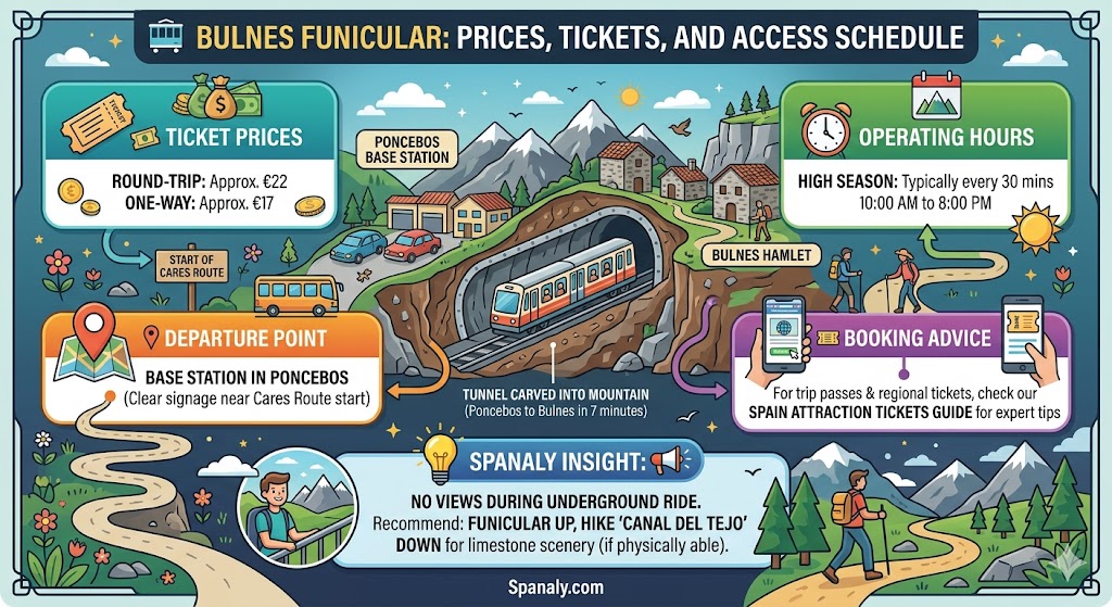
For those who want to reach the remote village of Bulnes without the steep 500-meter climb, the underground funicular is the only mechanical option. This tunnel, carved directly into the mountain, connects Poncebos to the hamlet in just seven minutes.
🎟️ Ticket Prices: Expect to pay approximately €22 for a round-trip ticket or €17 for a one-way trip.
⏰ Operating Hours: During high season, the service typically runs every 30 minutes from 10:00 AM to 8:00 PM.
📍 Departure Point: The base station is located in Poncebos, with clear signage near the start of the Cares Route.
🎫 Booking Advice: For managing your trip passes and other regional entry tickets, consult our Spain Attraction Tickets Guide for expert booking tips.
Spanaly Insight: While the funicular is convenient, it is entirely underground, meaning there are no views during the ride. If you are physically able, we recommend taking the funicular up and hiking the “Canal del Tejo” trail down to experience the limestone scenery.
🏔️ Naranjo de Bulnes (Picu Urriellu): Best Spots to View the Iconic Peak
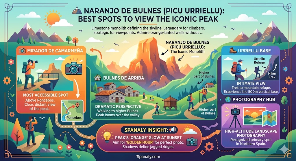
Naranjo de Bulnes is a massive limestone monolith that defines the skyline of the Picos de Europa. While it is a legendary destination for rock climbers, most visitors seek the best strategic viewpoints to admire its orange-tinted walls without a technical ascent.
📸 Mirador de Camarmeña: Located just above Poncebos, this is the most accessible spot for a clear view of the peak.
🏡 Bulnes de Arriba: Walking to the higher part of Bulnes village offers a dramatic perspective of the monolith looming over the valley.
🥾 Urriellu Base: For experienced hikers, the trek to the mountain refuge at the base provides the most intimate view of its 500-meter vertical face.
🌍 Photography Hub: This location is widely recognized as a primary spot for high-altitude landscape photography in Northern Spain.
Spanaly Insight: The peak gets its name “Naranjo” (Orange Tree) from the way the limestone glows during sunset. If you want the perfect photo, aim for the “golden hour” when the shadows define the jagged ridges of the central massif.
📸 Strategic Viewpoints (Miradores) You Can Reach by Car or Foot
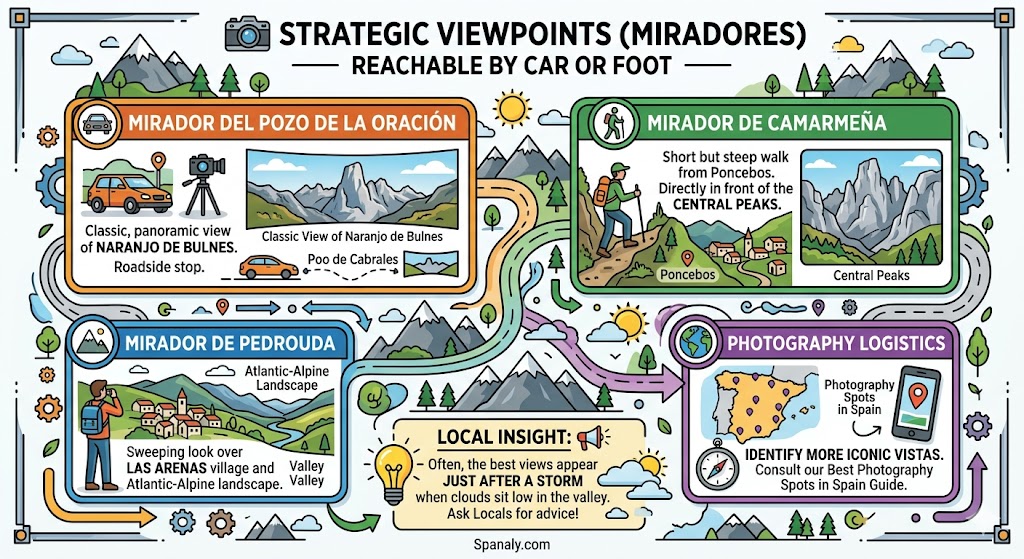
Finding the right perspective in the Picos de Europa often requires a mix of driving and short walks. These strategic “balconies” are positioned to offer the most comprehensive views of the limestone massifs and deep Asturian valleys.
🚗 Mirador del Pozo de la Oración: Located in Poo de Cabrales, this roadside stop provides the classic, panoramic view of Naranjo de Bulnes.
🚶 Mirador de Camarmeña: A short but steep walk from Poncebos that places you directly in front of the central peaks.
🏔️ Mirador de Pedrouda: Offers a sweeping look over the village of Las Arenas and the surrounding Atlantic-Alpine landscape.
🌍 Photography Logistics: For identifying more iconic vistas across the region, consult our guide on Best Photography Spots in Spain for expert location tips.
Some things aren’t written on the trail signs; you only learn them by standing in the mist and talking to the locals. Often, the best views appear just after a storm when the clouds sit low in the valley.
🦅 Wildlife and Nature: From Griffon Vultures to Cantabrian Forests
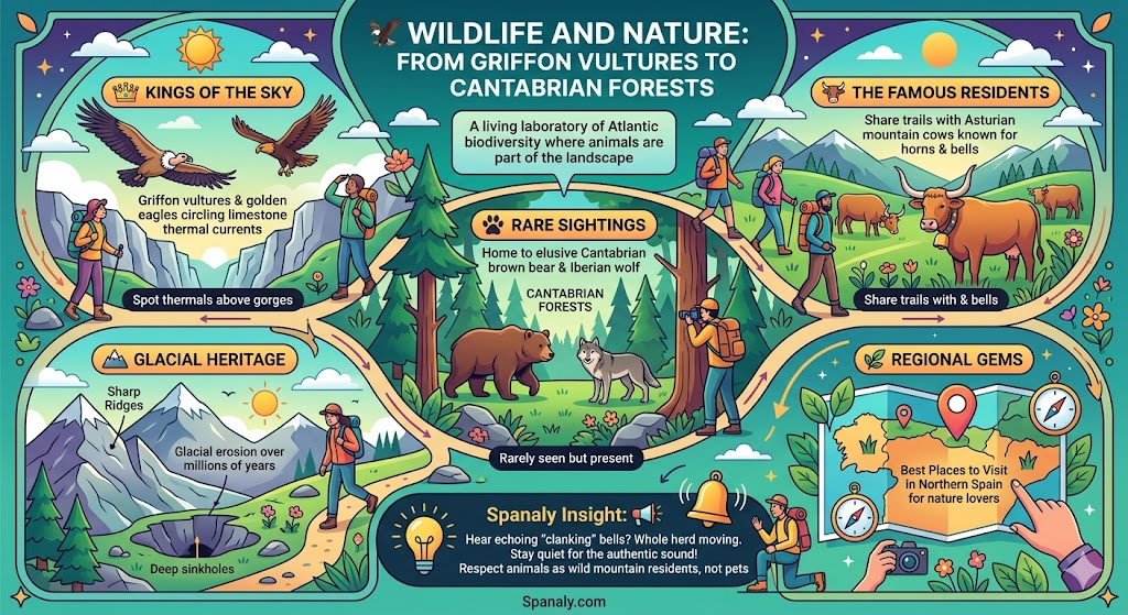
The Picos de Europa is a living laboratory of Atlantic biodiversity where animals are part of the landscape. You are walking through high-altitude pastures where nature dictates the daily rhythm, and the limestone crags provide a sanctuary for species rarely seen in other parts of Europe.
👑 Kings of the Sky: Spot Griffon vultures and golden eagles circling the limestone thermal currents above the gorges.
🐄 The Famous Residents: Share the trails with Asturian mountain cows known for their large horns and rhythmic bells.
🐾 Rare Sightings: The deep forests on the Asturias side are home to the Cantabrian brown bear and the Iberian wolf, though they remain elusive to most hikers.
🏔️ Glacial Heritage: The basin features sharp ridges and deep sinkholes shaped by ancient glacial erosion over millions of years.
🌿 Regional Gems: These peaks are among the Best Places to Visit in Northern Spain for nature lovers.
Spanaly Insight: If you hear a loud, echoing “clanking” sound, it’s the whole herd of cows moving. Stop and stay quiet to capture the most authentic sound of the Picos de Europa. Respect the animals’ space as they are wild mountain residents, not pets.
🚌 Getting There: Transport Options from Cangas de Onís & Oviedo
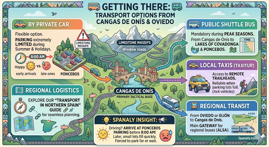
Reaching the Asturias side of the Picos de Europa requires strategic planning, as mountain roads are narrow and subject to seasonal restrictions. Most travelers use the historic town of Cangas de Onís as their primary tactical base before heading deeper into the limestone massifs.
🚗 By Private Car: Driving is the most flexible way to reach Poncebos, but parking is extremely limited during summer and holidays.
🚌 Public Shuttle Bus: During peak seasons, mandatory buses run from Cangas de Onís to the Lakes of Covadonga and Poncebos.
🚕 Local Taxis (Taxitur): Licensed 4×4 taxis offer access to remote trailheads and are a reliable alternative when parking lots are full.
🚉 Regional Transit: From Oviedo or Gijón, you can take a regional bus (ALSA) to Cangas de Onís, which serves as the main gateway.
🗺️ Regional Logistics: To understand how to navigate this area from major cities, explore our Transport in Northern Spain guide for seamless planning.
Spanaly Insight: If you are driving, arrive at the Poncebos parking area before 8:00 AM. After this time, the small lots fill up quickly, and you may be forced to park kilometers away or wait for a space to open in the afternoon.
🏘️ Where to Stay & Eat: Authentic Lodgings and Mountain Cuisine

Choosing where to sleep determines how early you can hit the trails and how much mountain atmosphere you experience. Staying in the valley offers more services, while staying in the high-altitude hamlets provides total silence.
📍 Cangas de Onís (The Base): The most practical hub with the best range of hotels and services. Stay at the Parador de Cangas de Onís for a luxury experience in an ancient monastery.
🏔️ Poncebos (The Trailhead): Ideal for hikers who want to start the Cares Route at dawn. Hotel Mirador de Cabrales offers direct access to the gorge path.
🛖 Bulnes (The Remote Escape): For a night of absolute isolation, book a room at El Redondo or La Casa del Chiflón in the lower village.
🧀 Mountain Fuel: After a day of trekking, try the legendary Gamonéu or Cabrales blue cheeses, often paired with a local cider (Sidra).
🍲 Local Flavors: For a deep dive into the region’s gastronomy, explore our Northern Spain Food Guide for must-try traditional dishes.
Spanaly Insight: If you choose to stay in Bulnes, remember that the funicular stops running in the evening. You will be “locked” in the village with only the sound of the stream and the stars a perfect experience for those seeking peace, but a logistics nightmare if you forget your essentials.
🌤️ Best Time to Visit: Weather Patterns and Seasonal Safety
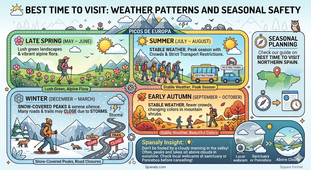
Timing is everything when visiting the Picos de Europa. The right window ensures clear views of the glacial peaks and a smoother logistical experience. The weather at high altitudes is vastly different from the valley, and Atlantic mist can cover the peaks in minutes.
🌸 Late Spring (May – June): This is the best time for lush green landscapes and witnessing the vibrant alpine flora.
☀️ Summer (July – August): Stable weather, but this is the peak season with significant crowds and strict transport restrictions.
🍂 Early Autumn (September – October): Offers stable weather, fewer crowds, and beautiful changing colors in the mountain shrubs.
❄️ Winter (December – March): Expect snow-covered peaks and serene silence, though many roads and trails may close due to storms.
🧭 Seasonal Planning: For a broader view of when to explore the region, check our guide on the Best Time to Visit Northern Spain.
Spanaly Insight: Do not be fooled by a cloudy morning in the valley. Often, the lakes and peaks sit above the clouds in bright sunshine. Check local webcams at the sanctuary or Poncebos before deciding to cancel your mountain trip.
⏱️ One Day in Picos de Europa: A Perfect Strategic Itinerary
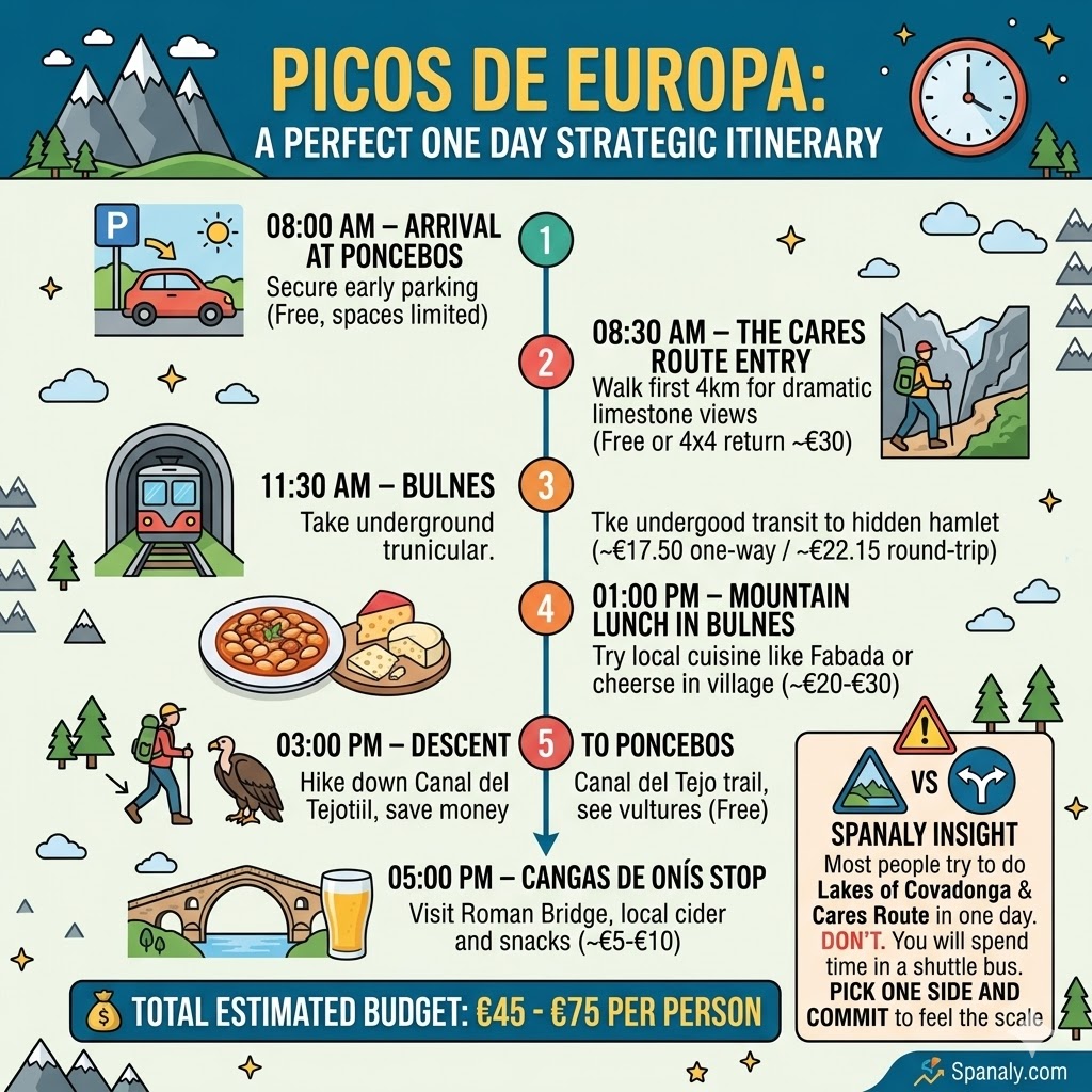
To master the Asturian peaks in 24 hours, you must operate with military precision. This plan starts early to beat the shuttle bus rush and ends with a deep dive into mountain gastronomy.
08:00 AM – Arrival at Poncebos: Secure a parking spot before the morning rush (Free if early, but spaces are gold).
08:30 AM – The Cares Route Entry: Walk the first 4km for the most dramatic limestone views (Free, unless you hire a 4×4 return taxi for ~€30).
11:30 AM – Bulnes Funicular: Take the underground transit to the hidden hamlet (~€17.50 one-way / ~€22.15 round-trip).
01:00 PM – Mountain Lunch in Bulnes: Try a hearty Fabada Asturiana or local cheeses in the village (~€20 – €30 per person).
03:00 PM – Descent to Poncebos: Hike down the Canal del Tejo trail to save money and see the vultures (Free).
05:00 PM – Cangas de Onís Stop: Visit the Roman Bridge and grab local cider before heading out (~€5 – €10 for snacks/cider).
💰 Total Estimated Budget: Expect to spend between €45 and €75 per person, depending on your choice of transport and dining.
Spanaly Insight: Most people try to do the Lakes of Covadonga and the Cares Route in one day. Don’t. You will spend your entire trip inside a shuttle bus. Pick one side and commit to it to actually feel the mountain’s scale.
💡 Spanaly Elite Tips: Insider Secrets for the Asturian Peaks

These tips come from the deep threads of local hiking forums and real-time traveler feedback. They focus on the small details that can make or break your mountain logistics.
🔕 The “Echo” Strategy: In the Cares Gorge, most noise comes from large groups. If you find yourself in a crowd, stop for 10 minutes, let them pass, and you’ll often have the next 500 meters of the canyon in absolute, eerie silence.
🔌 Power Bank Reality: Cold limestone walls and constant searching for a signal (which is almost non-existent) will drain your phone battery 40% faster than usual. Keep your phone in “Airplane Mode” to save power for photos.
🧴 The Sun Trap: Don’t be fooled by the 18°C temperature. The UV radiation reflecting off the white limestone is intense. Hikers often get severe “hidden” sunburns on their chin and neck because they only feel the cool breeze.
🎟️ Funicular “Shadow” Tickets: If the official website says tickets for the Bulnes funicular are sold out, check the physical ticket office in Poncebos early in the morning. They often hold a small contingent for walk-ins that isn’t reflected online.
👟 Sole Check: Don’t just bring “sneakers.” The limestone in Asturias is polished smooth by millions of footsteps and can be as slippery as ice when even slightly damp. Ensure your boots have deep, “sticky” rubber lugs.
🗺️ Budget Planning: For more ways to optimize your spending across the region, see our Northern Spain Travel Cost & Budget guide for realistic daily breakdowns.
Spanaly Insight: Locals in Poncebos know a secret: the best “post-hike” recovery isn’t a protein bar; it’s a piece of local blue cheese and a bottle of natural cider. It’s the traditional “high-altitude fuel” that has sustained Asturian shepherds for centuries.
🛡️ Visitor FAQs – Picos de Europa Asturias Logistics Guide
🎒 Can I leave my heavy luggage in Poncebos while hiking?
There are no official luggage lockers at the Poncebos trailhead or the funicular station. If you are not staying in a local hotel, we recommend leaving your heavy bags at your accommodation in Cangas de Onís or in your car trunk. Only carry a daypack for the steep mountain trails to ensure your safety and mobility.
🐕 Are dogs allowed on the Bulnes Funicular and hiking trails?
Yes, but with conditions. Pets can travel on the Bulnes Funicular if they are in a carrier or wearing a muzzle and a short leash. On trails like the Cares Route, dogs must be strictly leashed at all times to protect the local livestock (mountain cows and goats) and the fragile wildlife of the National Park.
📶 Is there mobile signal or Wi-Fi on the Cares Route?
Mobile reception is non-existent for about 90% of the Cares Route and the high-altitude trails. You are deep within a limestone gorge where signals cannot penetrate. Always download your offline maps and let someone know your expected return time before entering the trail.
🏧 Are there ATMs available in Bulnes or Poncebos?
No. Bulnes and Poncebos do not have ATMs. While many restaurants and the funicular office now accept credit cards, technical outages are common in the mountains. We strongly suggest carrying sufficient cash (Euros) for small purchases, local mountain cider, or in case the card machines lose connection.
🚕 Can I take a taxi from the end of the Cares Route (Caín) back to Poncebos?
Yes, but be prepared for a long journey. Although the hike is 12km, the road trip between Caín and Poncebos takes about 2.5 to 3 hours because the car must go all the way around the mountain massif. It is best to book a 4x4 shuttle service in advance, which can cost between €30 and €40 per person.
Picos de Europa Guide by Spanaly.com
The Picos de Europa (Asturias side) represent the raw, untamed heart of Northern Spain. Whether you are navigating the limestone corridors of the Cares Gorge or standing in the silent stone streets of Bulnes, this region offers a physical and spiritual connection to the mountains that is hard to find elsewhere in Europe.
🛡️ Respect the Scale: The mountains are indifferent to your plans; always prioritize safety and local weather warnings over your itinerary.
🧀 Taste the Tradition: Don’t leave without trying the local cider and blue cheese—it is the true “energy bar” of the Asturian shepherds.
🥾 Beyond the Gorge: While the Cares Route is legendary, the high-altitude glacial basins offer a completely different, mystical perspective.
🌊 Continue Your Adventure: If you want to witness the most iconic glacial lakes in the region, check out our Lakes of Covadonga Guide to complete your Asturian mountain circuit.
Spanaly Insight: The Picos de Europa don’t just offer a hike; they offer a perspective shift. There is a specific kind of clarity that comes from standing between 2,000-meter limestone walls with no mobile signal embrace it.